Duck River Valley — The Cycleway with Missing Links
 The Duck River rises in the gutters
and drains of Bankstown and flows north, entering the Parramatta
River at Silverwater. It has long been recognised as an
important feeder to the ecological health of the upper
Parramatta River. At first glance on a cycleway map it's hard to
follow, but if you are prepared to ride on quiet back roads
across a couple of short missing links the entire valley can be
followed. Being a river valley the steepest gradient is the rail
bridge at Clyde. It's an easy beginners ride with a quiet
introduction to on-road traffic situations.
The Duck River rises in the gutters
and drains of Bankstown and flows north, entering the Parramatta
River at Silverwater. It has long been recognised as an
important feeder to the ecological health of the upper
Parramatta River. At first glance on a cycleway map it's hard to
follow, but if you are prepared to ride on quiet back roads
across a couple of short missing links the entire valley can be
followed. Being a river valley the steepest gradient is the rail
bridge at Clyde. It's an easy beginners ride with a quiet
introduction to on-road traffic situations.
We start at Silverwater Park and head through the industrial area, empty of life on a weekend, soon there should be cycleway from Parramatta River to M4. After passing over the M4, we return to and cross Duck River on the cycleway bridge, and head to Martha St. The first major missing link is from here to Clyde rail station, but after crossing Parramatta Rd at the James Ruse Drive lights the railway station provides a quiet track crossing. Heading down Factory Street brings us to Mona St and the best part of the cycleway.
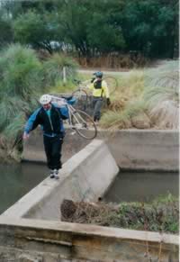
It follows the river for some lovely riding. Watch out for the ducks crossing the path and make sure you take a peek at the Japanese gardens just south of the baseball fields. After skirting the golf course the cycleway section comes to an end, just north of Norford Park. The best route south from here is across the river, and near the termination of Boundary Rd there is a small causeway that allows us to cross. (See photo ) Be very careful at the narrow bridge crossing the Pipeline in Hector St, resist the temptation of ale in Helen St, and find the railway underpass in Woods Rd. From here the canal is best followed beside Jim Ring Reserve, but stop for a drink and perhaps a picnic at Maluga Passive Reserve. There is an uninterrupted green space all the way to here from the causeway; one day this will carry cycleway, if we continue to dream and to work towards it.
The last major obstacle is the Hume Highway; and the small linear reserve at the end of Gascoigne Rd gives access to a set of traffic lights. A few metres down the next side street brings us to the Bankstown to Parramatta regional bike route which is a well signposted route to Bankstown or the Velodrome.
The Parramatta to Bankstown regional route was originally all on road, and for confident road riders still is a good option. However now that Auburn section of the Duck River cycleway and the M4/Fox St project are complete a trip between these two regional centres can now be enjoyed via this more scenic and relaxed route.
There's only 7 kilometres of cycleway to go to link Clyde to the ‘end of the track’ at Bankstown Velodrome. Write to your local member asking to get it finished. A completed loop from Clyde to Fairfield will be a real boost to cycling in this area.
Bay to Mountains Development
Adderley St now has an off-road path all the way from Duck River to Sydney Olympic Park, but the awful Silverwater Rd crossing remains. This means it is now possible to get from Cecil Hills to Meadowbank without putting a foot down except for comfort breaks, i.e. no traffic interruption whatsoever! Not one. The route is: Western Sydney Regional Park, Prospect Reservoir, Prospect Creek, Rail Trail, M4, Stubbs St, Silverwater industrial area, riverside path, Olympic park, Bicentennial Park then across old rail bridge. Truly amazing. It is now possible to do a century, 100 km, ride in Western Sydney on cycleways nearly all the way, and only three halts at traffic lights, Silverwater Rd, Hume Hwy and Horsely Drive. A truly awesome network is now available for us to enjoy!
