Cumberland Valley Cycleway — The final connection
It is a number of years since I was last seriously active as an advocate for this short piece of path. In fact, it’s been almost full term of state government. In that period the ‘Cumberland Valley Cycleway’ as I call it, has seen developments completed at both ends. The overall path network now extends an enormous distance. My vision of the “Cumberland Valley” path is a continuous good quality shared pathway from Old Windsor Road at Old Toongabbie to join the Lower Prospect Canal near Greystanes.
To the north the path beside Old Windsor Road and then Windsor Road has been completed as far as McGraths Hill and you can get off the road along an old bitumen track as far as the South Creek bridge. Connection to the railway station by Hawkesbury Council is only a matter of time.
To the South the Lower Prospect Canal has been connected into Pemulwuy (the old Boral estate) and to Orphans School Creek. However developments further south along Cowpasture Road now see continuous shared path going beyond the ‘ring’ of the M7 into Carnes Hill and Hoxton Park.
So it is now possible to ride the 24 km from Greenway Park at West Hoxton to Driftway Reserve at Pemulwuy on off-road shared path. It is also possible to ride the 24 km from South Creek at Windsor to Oklahoma Ave in Girraween on shared path. In the middle lies 1.5 kilometres of flat level ground. Why is there no path joining Girraween to Pemulwuy?
The answer is simple, the roads people have built a 4 lane motorway AND a 9 lane highway side by side here. Here’s a snapshot of the area in both Map and Satellite format.
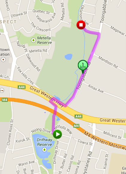
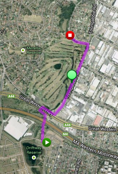
What is needed? Another simple answer. The distance between Oklahoma Ave and Driftway Reserve is a mere 1.2 kilometres. There is an ample wide footpath alongside Fox Hills Golf Course with a single driveway. There is an ample drain beneath the M4 motorway that the local council has identified as acceptable to carry a shared path. The answer is to actually build this path connection.
The roads and traffic designers created this impenetrable barrier to north/south cycling. They have built a wonderful network of paths to both the north and the south. The time has come to build the connection and bridge this awful gap. The highway here is 9 lanes wide with a speed limit of 80 kph. Vehicles regularly travel here at 100 kph as there are no buildings on either side of the highway. It is NOT a bicycle friendly environment at all. In addition, interrupting the right turn cycle of the traffic lights to allow cyclists enough time to cross such a wide road will adversely affect the traffic flow through the existing intersection. The ONLY answer is a bicycle/pedestrian bridge over the Great Western Highway. There is ample room to construct low grade ramps on both sides of the highway in the existing wide footpath easements.
This connection is not about linking Windsor with Hoxton Park. The M7 already does that. It is about connecting all of the places between the M7 at Baulkham Hills and Girraween with all of the other places between Pemulwuy and the M7 at Hoxton Park. It is about getting from Toongabbie to Wetherill Park, Northmead to Greystanes or Seven Hills to Guildford. All of these trips and many more become possible with this connection.
In June, 2014 CAMWEST members met with the Minister for Roads and RMS staff and received a very positive response to this connection. The RMS will investigate and plan a path underneath the M4 and join to the existing traffic lights, where the traffic cycle will be altered to allow for the cyclists crossing. We will continue to campaign for an overbridge. Holroyd Council can then apply for funding to lay concrete between Oklahoma Ave and the Great Western Hwy.
\